Tuesday, September 29, 2009

A Shift in the Wind

The Midwest is gorgeous in the fall... as are most places, I suppose. We have shifted the clothes in our duffel bag - moving the shorts to the bottom and long stuff on top. And I am resisting the need to retire my Chacos for the season, no matter how cold my toes get.


Ladies and Gents, the inevitable is here... we are running out of time and will not be able to see every state in this incredible country. Very sad, very sad. So it is Northeast or Bust for us! We hope to get to Maine within the next month, see some pretty leaves and lighthouses, and then head along the east coast before the hardcore winter begins.


Quick question for you... If the Dakotas, Minnesota, Wisconsin, etc. are called the Midwest, then what are Montana, Wyoming, Utah, Nevada, etc. called? The Left West? The 3/4s of the Way West? The Real West?

Well, whatever you choose to call that area... sadly, we will miss it. The good news is those natural features have been there for hundreds of thousands of millions of years. We hope they can survive the next 2+ years until we get back. It is a part of the nation we'd like to explore. Anyone up for joining us on the Pacific Crest Trail?

__________________________________________


On our way east, we decided to stop in Pierre - South Dakota's state capitol. And our blog would not be complete without some facts!
  • Built between 1905 and 1910
  • 114,000 square foot structure
  • Materials include native field stone, Indiana limestone, and Vermont and Italian marble.
  • 161 feet tall, 292 feet long
  • Designed and built for just under 1 million dollars
  • It is a modified version of Montana's State Capitol
  • Currently valued at 58 million dollars
  • The "Capitol Annex" was added in 1932 at the request for more office space


The "Blue Tile" Legend:
Sixty-six Italian artists were hired to lay the terrazzo tile throughout the capital building. Most artists leave their signature on their work, and each Italian artist was given a blue "signature stone" to place wherever they'd like. But only 55 of the 66 blue stones have ever been found. We found 5.

Brass buttons were installed during the 1940's renovation in order to provide engineers with elevation reference points throughout the building. Every 5 years, engineers check the reference points and determine if the foundation has moved with the expansive soil. We saw one brass button.


The Rotunda is 96 feet from where I'm standing to the interior center, and is 161 feet from where I'm standing to the exterior center.


The Warrior Eagle Staff is said to be the first flag used by Native American people. The one pictured above (right) is wrapped with smoked buffalo hide and strung with beads and eagle feathers over green willow branches.

South Dakota has been under 4 different governments:
  • French
  • Spanish
  • Dakota Territory
  • United States


The capitol grounds are perfectly manicured, and include numerous memorials. An eye-catching one contains six life-size bronze statues, each representing roles of soldiers during World War II, and pays tribute to the 65,000 South Dakotans involved in the war.

Directly in front of the bronze statues is the Flaming Fountain Memorial with a flowing artesian well containing natural gas. You could smell the sulphur when we arrived. The gas was ignited as a background for the surrounding memorials, but it was not lit while we were there.

__________________________________________


If you are going to visit South Dakota, don't forget to see The World's Only Corn Palace!

The idea for the palace came from Louis Beckwith and L.O. Gale to showcase the crops grown in the area and attract immigrant farmers to settle in the area. The first palace was built in 1892 (for just under $3,000), and a Corn Palace Festival kicked off the harvest. Both traditions continue today!


The corn murals have to wait until late summer when the corn crop is ready. We arrived in time to witness the transition. 2009's theme was "America's Destinations" and included images of Mt. Rushmore, the Space Needle, and the Statue of Liberty.


And 2010's theme is "Through the Ages" and will display modes of transportation. Two guys were nailing half-husks to form an airplane.

  • It takes around $130,000 to redecorate the Corn Palace each year.
  • 3,000 bushels of milo, rye, oat heads, and sour dock are tied in bundles and border each image.
  • Over a half million ears of corn, in 12 different colors, are sawed in half and nailed to the building.
  • New murals are transferred onto black roofing paper, then the corn is nailed in. The lady at the palace said to think of it as a large "Corn-by-Color." Heehee - A Corn Palace joke!

Monday, September 28, 2009

Les mauvaises terres a traverser - The Badlands

"Whatever your feelings about the Badlands, you will not come away unaffected."
-NPS Badlands Brochure

The Badlands seem desolate, but are teaming with life. There are over 60 species of grass, hundreds of species of wildflowers, and animals like the prairie dog, black-footed ferret, bison, deer, and more! The park contains 240,000 acres and is surrounded by the Buffalo Gap National Grasslands to the north, and the Pine Ridge Indian Reservation to the south.


There are three park units, two of which are in the Pine Ridge Indian Reservation. We spent our time in the North Unit - 64,000 acres of astonishing emptiness.


Our days were spent traveling the Badlands Loop Road, the Sage Creek Rim Road, and hiking various trails throughout the park. We hiked the Cliff Shelf, Notch, Window, and Door trails. We also searched for the Cubby Hole, Pantry, Door Knob, and Window Pane trails, but didn't see them. Haha - Badlands joke!

The "ladder" on the Notch Trail.


The Badlands experience constant erosion by the winds and rains, and this erosion produces numerous shapes. We saw curves and sharp edges, smooth surfaces, and beaded streams.

Richie saw these from the overlook and thought of boobs!

We were most fascinated by the colorful layers throughout the park and the variety of textures. There were black and gray layers, yellows and reds, crumbling, chalk-like shards, and hard, solid rock. Within these layers are the highest concentration of fossils in the world.


You could see one stripe on a peak aligned with the same stripe on a peak 400 yards away. How can that be? What happend to the 400 yards between each peak? And knowing that each stripe, each layer, holds a story of the time within its clay and dirt, is incredible to think about. Not to mention the millions of years between each layer!


The very top layer, known as Sharps Formation, was deposited 28-30 million years ago - - The Top Layer! And the black layer at the wee bottom, the Pierre Shale, was deposited between 60 and 75 million years ago.


These mounds reminded me of painted Easter eggs. Where do the red and yellow colors come from, you ask? Sediment flowed throughout the shallow sea (once covering the Great Plains). As the water receded, the sediment developed into a black mud called Pierre Shale. When the mounds of the Black Hills began pushing through the sea, causing water drainage, the newly exposed shale turned yellow. With the growth and decaying of the forests, the new sediment turned into red soil. The park labels the mounds Yellow Mounds Paleosol and the Interior Paleosol.


The bunny rabbit admiring our tent, and patiently awaiting a bite to eat.
These little guys were everywhere!

Sunday, September 27, 2009

The George S. Mickelson Trail


Fall is a wonderful time for a bike ride. The air is crisp and the weather is not too hot or too cold. With this ideal weather ahead, we searched the reliable Rails-to-Trails site for nearby bicycle trails in the Black Hills of South Dakota. The George S. Mickelson sounded like a nice challenge - 109 miles from Edgemont to Deadwood.

Unlike the Katy Trail, we decided to camp along the Mickelson Trail. The B&B's of the Black Hills aren't conveniently spread out, nor are they as reasonably priced.

It took us a few days to plan, and a few more days of waiting for the big annual Mickelson Trail Trek to finish. We figured our wait would guarantee availability at trailside campgrounds.

Unfortunately, there was no Amtrak to take us to the end of the trail this time, and we weren't up for paying $50/person for a van to shuttle us down there. (Gosh, looking back, cost seemed to be an issue on this adventure! Mom - send money, please!!! Just kidding.) So we planned on biking all 109 miles and back again - for a total of 218 miles (maybe a bit more). It seems each time we bike, we go a little further than the trail before.

Our itinerary looked like this:

Day 1: Deadwood to Hill City - 50 miles
Day 2: Hill City to Edgemont - 60 miles (50 miles downhill)
Day 3: Edgemont to Custer - 49 miles + 4 miles into Custer State Park
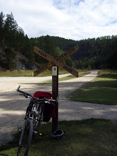
Day 4: Custer to Rochford - 38 miles
Day 5: Rochford to Deadwood - 27 miles


We learn so much on this road trip, and we hope you aren't annoyed by all that we share. There is just so much to absorb! Here are some facts about the George S. Mickelson Trail:
  • Part of the Burlington Northern rail line.
  • It was abandoned in 1983.
  • Named for Governor George S. Mickelson, a key supporter in the trail conversion. He was killed in a plane crash back in 1993.
  • The tracks were laid in a little over 100 days, but it took 15 years to convert the tracks to a trail.
  • The trail was completed in 1998.
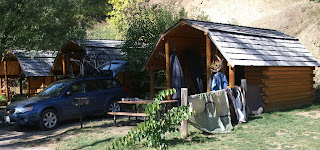
The night before our ride, we rented a "kabin" at a KOA (Kamprounds of America). No one should be allowed to advertise with this much yellow. (And yellow is my favorite color, by the way!) It was our first experience with KOA - and it was a good one. A great alternative to nearby hotels - about 1/3 of the cost! The cabin, oops... "kabin," gave us more space to spread out our gear, do inventory, pack, and the roof kept us dry.

All week, I was nervous about the weather. It was raining and cold, not to mention the hang-on-to-the-street-sign winds. We checked the weather daily - an unusual idea for us - but with the guaranteed winter ahead, it is a habit we should get into.

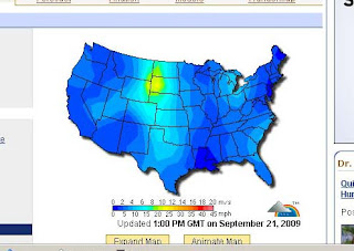
This is the wind map of the U.S. just before our bike ride.
See that nice yellow oval in South Dakota?
That's right over the Black Hills!

My prayers about the weather were answered. We woke up to pretty blue skies and cool enough weather to warrant our layers.

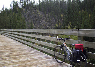
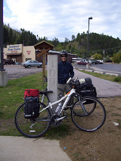
We left Sally the Subaru at the Deadwood trailhead (mile post 109), and started on the 50-mile day to Hill City.


Some quick facts about Deadwood:
  • It was named for the burned trees found by miners
  • Final resting place of Wild Bill Hickok and Calamity Jane.
  • It is a gambler's delight with over 80 "gaming establishments" in a population of about 1500.
My biggest concern for this ride was the weather, but it should have been the significant elevation change along the trail. The pamphlet says "With its gentle slopes and easy access, people of all ages and abilities enjoy the beauty of the Mickelson Trail in the Black Hills." Well, the brochure failed to mention the insanely difficult 15 miles at the start of the trail. We now know why the annual Mickelson Trail Trek starts in Edgemont and ends in Deadwood!


We cooked lunch at the Rochford trailhead. Some facts about Rochford:
  • Known as "The Friendliest Little Ghost Town in the Hills"
  • It was founded in 1877 to support local mining.
  • The railroad reached Rochford in 1889.
  • And the last native black bear in the Black Hills was killed near Rochford in 1968.


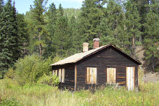
Our next break was in Mystic, an old mining town:
  • Originally named "Sitting Bull."
  • Founded in 1880's as a mining town.
  • Name changed to Mystic in 1889.
  • Served as the western terminal of the Rapid City, Black Hills and Western Railroad. It was also a station on the Chicago, Burlington and Quincy Railroad.
  • The last passenger train stopped at Mystic in July 1947.
  • The last freight train went through in November 1983.
  • Mystic closed when the George Frink sawmill closed in 1952.

By the time we reached Hill City, we were exhausted.
We always want to be encouraging and positive for each other in situations like this, but at mile post 70, we were both quietly thinking the same thing: "Why are we doing this?"

Our bodies were telling us they weren't ready for 5 days of ups and downs. So, we both agreed to spend an extra night at the Crooked Creek Campground, about 2-miles from Hill City.

Some quick facts about Hill City:
  • It was established as a gold camp in February 1876.
  • The second oldest town in the Black Hills (Custer being the oldest).
  • Known as "The Heart of the Hills"
  • They love their sports teams - Go Rangers!

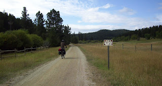
The "W" sign was a reminder to train engineers to blow the train whistle
to warn people and animals near road crossings.
The pattern: 2 long, 1 short and 1 long blast.

I read great reviews about The Bumpin Buffalo, so we walked into Hill City for dinner. The 4-mile round-trip was great "active recovery!" We were starving and loaded up on salad, sweet potato "chips," and salmon. It was good enough. We scoped out the coffee shop down the street and decided we would spend the morning there reading and resting.

The next morning we woke up feeling pretty good, but glad we had picked today as a recovery day. On the day's itinerary was another 4-mile walk into town, some good coffee, some good book-reading, and a tasty lunch. As we walked down the path, absorbed in conversation, we saw a black streak fly past us! It was a black cat, probably about a year old. Now most people would think this would be bad luck, but that cat kept us entertained for at least a mile. She would stop, sniff around on the side of the trial for a bit, then ZOOM past us again. That cat must have thought she was a dog!

While we have not been impressed with the food selection here in South Dakota, we were overjoyed when we arrived at The Alpine Inn. This German-style restaurant cooked up some yummy comfort food. We highly recommend it!

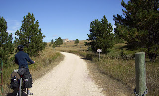
Can you see the Crazy Horse Memorial in the background?

We made reservations at Custer State Park for our third night, so we loaded our gear and biked 15 miles south into the town of Custer. It was a refreshing ride, with no pressure to get to point B before nightfall. We zoomed, but only because it was mostly downhill, past Crazy Horse and beautiful landscapes, and thoughts of climbing up these hills tomorrow, in the back of our minds.


Our one frustration with South Dakota State Parks has been their lack of signage and crappy maps. The map of the park showed two camper icons north and south of Stockade Lake, so we thought it would be easy enough to find the South Stockade Campground. Uhmmm... Nope! After circling an extra 10 miles, we finally found the South Stockade Campground. When we arrived, the camp host was roughly scooping black wood from a neighboring campsite. The previous night's campers built a fire outside of the fire ring. He smiled and confirmed our reservations for the evening. Nice fellow.


The next morning, we biked into Custer for breakfast at Baker's Bakery and Cafe. Adorable! The staff were friendly and joked with customers. Richie had their hubcap-size pancakes and I had their muffler-size breakfast burrito. Thankfully, they had to-go boxes that fit on our bikes. No worrying about lunch, now!

We hope you enjoy their logo as much as we did... very clever! Click here.


______________________________

Can we rant for a minute or two, please?

Reading seemed to be this week's theme instead of riding... and we both happened to have completed books ready to trade. While in Custer, we spotted a used book store named The Reader's Retreat.

We were greeted by a sweet dog - playful, yet nervous.

As we entered the store, we saw an angry woman organizing books (we'll call her The Woman). She was commanding the dog to get behind the clerk desk, and she seemed annoyed. The husband (we'll call him The Husband) appeared and told us that the dog was a shelter animal and that she gets really nervous when people come into the store. He asked us to ignore the dog and look at the books. Richie and I looked at each other and said under our breath "Well, if you don't want customers playing with your dog - don't bring her to the store!"

I asked The Woman if they could search their collection by book title (I didn't recall the author's name). She gave me a queer look, avoided the computer, and sharply asked "What are you looking for?"

I couldn't believe this woman was talking to a customer this way! I told her the title Divorce Your Car. She looked at me disgusted and said "Divorce Your Car? Is that a book about divorce or something?" I told her the book was about reducing car usage, and might be in the biking section, but I didn't see it. And without even looking, the woman said "No!"

We finished looking through the selection of books, and each found something we were interested in. Meanwhile, The Husband was barking directions at The Woman (no pun intended).

The Husband was nice enough in exchanging our books, and we quickly went on our way. We spent the next 10 miles in disbelief at the experience.

So if you are in Custer, South Dakota... We highly recommend Baker's Bakery and Cafe, but we discourage a visit to The Reader's Retreat.

Thanks for listening.

______________________________

It was 11am before we left Custer. The night before, we had toyed with the idea of biking to Deadwood (a whopping 70 miles!), or "disperse camp" in the National Forest near the Rochford trailhead. We arrived at the Rochford trailhead, both feeling capable and excited with the full 70-mile challenge to Deadwood, so off we went.


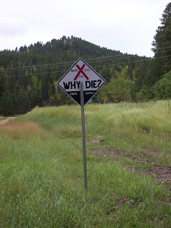
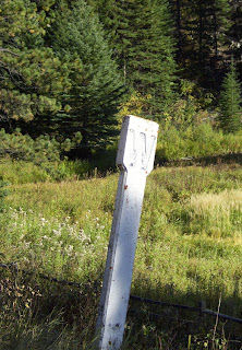
There are signs like this one along highways throughout South Dakota. They are "fatality markers." You can read more about them here.

We arrived at the Deadwood trailhead at 7:15pm. The sun set almost 20 minutes before, and our fingers and toes were frozen, tummies growling.


We arrived a day early at the KOA campground, exhausted, but thankful they had a cabin... urgh... "kabin" available. After a defrosting shower, we ordered pizza, watched a movie on the computer, and zonked out. We spent the next day washing clothes and airing out the tent and sleeping bags.

Saturday, September 19, 2009

Back at Bear Butte State Park


With a few days before our rails-to-trails ride, we decided to take advantage of the $8/night price at Bear Butte State Park, plus we wanted to hike to the top of this oddly placed mountain.

We were welcomed back to Sturgis with 30 mph winds, which made for an interesting hike. Richie and I related the experience to our summit of Mt. Rainier - when we were leaving Camp Muir for high camp. I remember the three of us (Megan, Richie, and I) were constantly being blown down due to extreme wind. It was a very scary moment.


Luckily, there was no snow, but the drop-off was still spooky.

From the 4,426-foot peak, we had an uninterrupted view of the Black Hills.

The Black Hills are named for the Ponderosa Pines' dark bark (say that 3 times fast!), which viewed from a distance, and in bulk, look black!

Bear Butte Lake
Can you see our tent? Its the one with the orange sides... see it?


We could also see Fort Meade (birthplace of the Star Spangled Banner?) and the motorcycle town of Sturgis.

The geology of Bear Butte...
Molten rock attempted to push through the Earth's surface, but never did - a volcano that failed to erupt. Over time, the layers of the volcano have eroded, leaving the butte.


In August 1996, over 800 acres of the butte burned due to a wildfire. Some of the blackened tree trunks can still be seen.

The trail is also lined with colorful pieces of cloth tied to the trees. Bear Butte is a sacred mountain - and is still a place of worship for the Lakota tribe.


They are called prayer clothes, and the colors are related to the four directions (north, south, east, and west).

The spirit of the mountain is strong (or maybe that was just the wind!)... and walking among the prayers was a peaceful experience.


In our visits back to Sturgis, we happened upon a delightful place called Olde Worlde Cafe and Bookery. Free Wi-Fi, great music, and Dan makes a mean cup-o-coffee! So if you are ever in Sturgis, South Dakota - stop by the cafe for a comforting smile, good food, and a beverage.

Dan said their website should be up soon... www.oldeworldecafe.com
Address: 923 Junction Avenue Sturgis, SD

Thursday, September 17, 2009

Peter Norbeck National Scenic Byway, Harney Peak, & Custer State Park


The Black Hills are wonderful. Every curve in the road presented a new and exciting thing to watch and learn. It is a great place to explore.


We spent 2 nights in Custer State Park and traveled the loop of highways known as the Peter Norbeck National Scenic Byway.

Who is Peter Norbeck?

He served numerous political roles - South Dakota State Senator, Lt. Governor, South Dakota's 9th Governor (and first native Governor, by the way), and finally a U.S. Senator.

He founded Custer State Park and was the initiator of the Needles and Iron Mountain highways (which is why the collection of highways are named after him). He convinced Borglum to carve Mt. Rushmore, and was a key fundraiser for the project. He had a hand in preserving the Badlands National Park and other conservation projects.

The string of highways can be very confusing, unless you are a local or a guest with a good map. The locals weren't available because just about every place we stopped at was closed for the season... and the map(s) we found only caused more confusion. But we managed to find our way.


Iron Mountain Road (Highway 87):
  • Designed by Cecil Clyde "C.C." Gideon
  • 3 tunnels, each framing Mt. Rushmore
  • 3 Pigtail Bridges
  • Completed in 1933 by 16 men


Gideon needed a way to connect the 3 existing tunnels without leveling the steep terrain, so he built 3 structures called Pigtail Bridges.


The Pigtail Bridges historic marker reads:

In 1932, Cecil Clyde Gideon forged ahead with the design of the Pigtail Bridges when many felt it could not be done. C.C., as he was called, was a pioneer in the Black Hills, making his mark as a master builder, architect, craftsman, lawman, and highway designer. Riding horseback from his home at the Game Lodge, Gideon and Senator Norbeck spent long hours laying out the Iron Mountain Road, the tunnels that frame Mount Rushmore and these bridges. Norbeck wanted a rustic look but elevation drop presented complex engineering problems. These bridge surfaces are neither straight, level nor flat and rustic log work has great variation in quality. Logs were selected from nearby, cut to fit, seasoned, then put in place. With the completion of the bridges more scenic beauty of the Black Hills became available for all people to enjoy.

Needles Highway (State Highway 16A):
  • Mapped in 1919
  • 150,000 pounds of dynamite used
  • Completed in 1922
  • 14-miles long
  • Due to its initial cost, locals referred to the roadway as the "Needless Highway"
We thought this was a funny site. A view finder post without the view finder.
And it still had the sign requesting 25 cents!

The Cathedral Spires
(Named for the towering peaks which appear like organ pipes.)

The Needles Eye

Both are made from granite, formed underground from magma that was pushed upward millions of years ago, and cooled very slowly. Rock climbers come from around the world to challenge themselves on these awesome formations. We saw 3 when we arrived at the Needles Eye.


A cute story from one of the road signs...

Norbeck was seeking national financial support for the Black Hills project, and invited numerous people with political connections. In 1927, Coolidge stayed at the State Game Lodge in Custer State Park. He took up fly fishing. The reader board said this of President Coolidge:

Little did he know that his fishing skills were greatly enhanced by the undercover work of the park officials. Chicken wire was stretched across the creek upstream and downstream from the President's quarters and large trout from a nearby fish hatchery were planted nightly. Coolidge couldn't help but fill his creel!

Our next stop was a 6-mile round trip to the highest point in South Dakota - Harney Peak at 7,242 feet!


It is the most popular hike in the area, and this day was no different. We followed a group of middle-schoolers to the half-way point. While they took advantage of a great group photo opportunity (and a much requested break), we continued the uphill hike.


It was fun to follow them as far as we did. They were a curious group with lots of questions. It was refreshing to see the 50+ students and chaperons in the great outdoors - and enjoying it!


The weather was, once again, spectacular. And the views were incredible. It reminded me of our Mt. Tamalpais hike in California, except there were no ocean views.


The sun would be setting soon, so we decided to take advantage of this ideal time to view wildlife on Custer State Park's 18-mile Wildlife Loop Road. We were not disappointed.


The most exciting and anxious moment for us was when we drove through the Buffalo Corrals. While these are fenced areas of the park, there are still bison in the road... slowly crossing the road.


At the end of September (the 26-28th to be exact), Custer State Park hosts The Buffalo Roundup and Arts Festival. Craftsman and artists display their works, cowboys and cowgirls "roundup" the park's bison, visitors witness bison branding and vaccinations, and the park auctions about 400 bison. It is a big deal.


Some facts about Custer State Park:
  • Named for George A. Custer (led army expedition into Black Hills in 1874 - found gold!)
  • Started as a state game reserve
  • Became a state park in 1919
  • 71,000 acres
  • 4 Lodges: State Game Lodge, Sylvan Lake Lodge, Blue Bell Lodge, and Legion Lake Lodge (all very expensive - starting at $130/night... eek!)
  • 1,500 head of bison
  • 1,000 elk
  • And to our surprise, a small herd of "begging burros" that approached us when we arrived. We were lucky, but this car wasn't fast enough. As we passed, the couple inside was in hysterics, laughing.
And this little guy saw me sneak a picture. If swear if he could talk, he would have said "That picture will cost you a carrot, miss!"